Sea maps
Sea temperature, salinity, ocean currents, and sea height are based on model calculations.
The forecast longer than 48 hours (2 days) is available only to Neverin subscribers.
Current status of weather models
| Model | Run | Start | End | Next update |
|---|---|---|---|---|
| CMEMS MEDSEA | 0 UTC | 09.07. 14:20h | In progress | 10.07. 18:20h |
- 0h
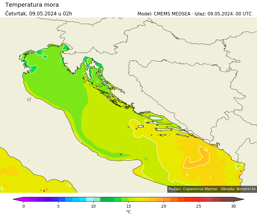
Sea temperature
Sea temperature refers to the surface layer of the sea and is expressed in °C.
Sea salinity
The salinity of the sea is the amount of dissolved (grams) salt in one kilogram of seawater, expressed in parts per thousand (‰). Numerous salts are dissolved in seawater, among which chloride salt NaCl prevails, known as table salt. The average salinity of the world's oceans is 35‰, meaning that on average, 35 grams of salt are dissolved in one kilogram of seawater. In one kilogram of seawater of the Adriatic Sea, an average of 38 grams of salt is dissolved.
Several factors affect the salinity of the sea, among which the most important are the strength of water evaporation, the amount of precipitation, the inflow of freshwater from land, and the enclosure of the sea. The higher the water evaporation and the lower the amount of precipitation, the higher the salinity will be. The greater the inflow of freshwater from rivers, the lower the salinity will be. Enclosed seas experience higher evaporation and higher salinity.
Sea currents
Sea currents are circular movements of seawater and they facilitate the exchange of water in the sea. By far, the most significant cause of sea currents are constant winds. They generate waves and, through friction, push the surface water mass, resulting in persistent currents. Besides wind, sea currents are influenced to a lesser extent by the gravitational force of the Moon, Earth's rotation, differences in temperature and salinity of the world's seas, and river flows.
Sea currents in the Adriatic sea are an integral part of the system of Mediterranean sea currents. They move in a counterclockwise direction, and the main reason for this is the rotation of the Earth. Therefore, the warm current passes along the eastern (Croatian) coast and exits along the western (Italian) coast. As the Mediterranean Sea is a relatively enclosed sea, sea currents in all its parts, including the Adriatic, are relatively weak. Sea currents along the Croatian coast move slower than along the Italian coast due to the large number of islands on the Croatian side of the Adriatic.
Sea height
Sea height displays the surface height of the sea above the geoid. The geoid is a surface of constant geopotential with which mean sea level would coincide if the ocean were at rest. Tides are included in the calculation.
Data source
- E.U. Copernicus Marine Service Information; https://doi.org/10.25423/CMCC/MEDSEA_ANALYSISFORECAST_PHY_006_013_EAS8


